Faýl:Korean war 1950-1953.gif
Bu synlawyň ölçegi: 387 × 600 piksel. Other resolutions: 155 × 240 piksel | 562 × 871 piksel.
Original faýl (562 × 871 piksel, faýlyň ölçegi: 1,32 MB, MIME tipli: image/gif, halkaly, 20 kadr, 30 s)
Gysgaça düşündiriş
| Düşündiriş |
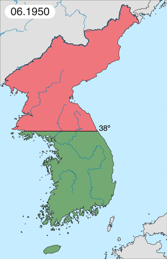
English: Map of Korean war from May 1950 to July 1951, showing:
Français : Carte de la guerre de Corée de mai 1950 à juillet 1951, montrant:
Deutsch: Karte des Koreakriegs von Mai 1950 bis Juli 1951, abgebildet:
Italiano: Mappa della guerra di Corea dal maggio 1950 al luglio 1951, rappresentante:
|
| Sene | |
| Çeşme | Öz işi (eseri) |
| Awtor | Leomonaci98 |
Lisenzirleme
I, the copyright holder of this work, hereby publish it under the following licenses:

|
Permission is granted to copy, distribute and/or modify this document under the terms of the GNU Free Documentation License, Version 1.2 or any later version published by the Free Software Foundation; with no Invariant Sections, no Front-Cover Texts, and no Back-Cover Texts. A copy of the license is included in the section entitled GNU Free Documentation License. |
| Bu faýl Creative Commons Attribution-Share Alike 3.0 Unported lisenziýasyna laýyklykda lisenzirlenendir. | ||
| ||
| This licensing tag was added to this file as part of the GFDL licensing update. |
Islän lisenziýaňyzy saýlap bilersiňiz.
Faýlyň taryhy
Faýlyň geçmişini görmek üçin Sene/Wagt bölümündäki senelere tyklaň.
| Sene/Wagt | Miniatýura | Ölçegler | Ulanyjy | Teswir | |
|---|---|---|---|---|---|
| häzirki | 20:20, 16 fewral 2020 | | 562 × 871 (1,32 MB) | Leomonaci98 | Graphic update |
| 01:02, 1 maý 2013 |  | 227 × 400 (85 KB) | Spesh531 | update for every month | |
| 08:47, 9 iýun 2006 |  | 227 × 400 (37 KB) | Roke~commonswiki | rm white | |
| 06:25, 8 iýun 2006 |  | 227 × 400 (37 KB) | Roke~commonswiki | add OngJin peninsula after comment, also blank frame at end | |
| 15:14, 5 iýun 2006 |  | 227 × 400 (37 KB) | Roke~commonswiki | Korean war, showing North Korean, Chinese and communist forces (red); South Korean, US and United Nations forces (green). Category: Korean War Category: Animated maps |
Faýlyň ulanylyşy
Bu faýla çykgydy bar bolan sahypa:
Global faýl ulanyşy
Bu faýl aşakdaky beýleki wikiler tarapyndan ulanylýar:
- af.wikipedia.org sahypasynda ulanyş
- az.wikipedia.org sahypasynda ulanyş
- bat-smg.wikipedia.org sahypasynda ulanyş
- bg.wikipedia.org sahypasynda ulanyş
- br.wikipedia.org sahypasynda ulanyş
- bs.wikipedia.org sahypasynda ulanyş
- ca.wikipedia.org sahypasynda ulanyş
- Corea del Nord
- Corea del Sud
- Ióssif Stalin
- Mao Zedong
- Winston Churchill
- Harry Truman
- Guerra de Corea
- Kim Il-sung
- Viatxeslav Mólotov
- Gueorgui Malenkov
- Douglas MacArthur
- Lavrenti Béria
- M*A*S*H (pel·lícula)
- Clement Attlee
- Mark Wayne Clark
- Zona desmilitaritzada de Corea
- República Popular d'Hongria
- Syngman Rhee
- Peng Dehuai
- Força Aèria de l'Exèrcit Popular de Corea
- Forces Armades de Corea del Nord
- Forces Armades de la República de Corea
- 65è Regiment d'Infanteria (Estats Units)
- Frontera entre Corea del Nord i Corea del Sud
- Kim Chaek
- Batalla d'Inchon
- Plantilla:Guerra de Corea
- Pak Hon-yong
- ckb.wikipedia.org sahypasynda ulanyş
- cs.wikipedia.org sahypasynda ulanyş
- cy.wikipedia.org sahypasynda ulanyş
- da.wikipedia.org sahypasynda ulanyş
- de.wikipedia.org sahypasynda ulanyş
- el.wikipedia.org sahypasynda ulanyş
- en.wikipedia.org sahypasynda ulanyş
Bu faýlyň global ulanyşyny görkez.