Faýl:South Asia (orthographic projection) without national boundaries.svg

Size of this PNG preview of this SVG file: 550 × 550 piksel. Other resolutions: 240 × 240 piksel | 480 × 480 piksel | 768 × 768 piksel | 1 024 × 1 024 piksel | 2 048 × 2 048 piksel.
Original faýl (SVG faýly, nominal 550 × 550 piksel, faýl ölçegi: 2,8 MB)
Gysgaça düşündiriş
| Düşündiriş |
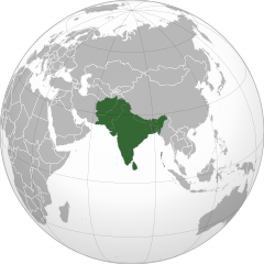
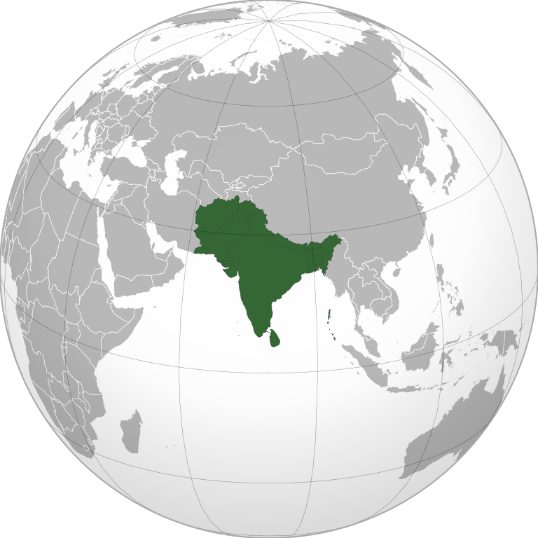
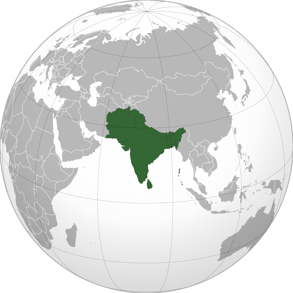
English: South Asia |
||
| Sene | (UTC) | ||
| Çeşme | |||
| Awtor | user:Serg!o | ||
| Beýleki wersiýalar |
.svg) |
||
| SVG genesis |
|
.svg)
.svg)
.svg)
.svg)
.svg)
.svg)
.svg)
.svg)
.svg)
.svg)
.svg)
.svg)
.svg)
.svg)
.svg)
.svg)
.svg)
.svg)
.svg)
.svg)
.svg)
.svg)
.svg)
.svg)
.svg)
.svg)
.svg)
.svg)
.svg)
.svg)
.svg)
.svg)
.svg)
.svg)
.svg)
.svg)
.svg)
.svg)
.svg)
.svg)
.svg)
.svg)
.svg)
.svg)
.svg)
.svg)
.svg)
.svg)
.svg)
.svg)
.svg)
.svg)
.svg)
.svg)
.svg)
.svg)
.svg)
.svg)
.svg)
.svg)
.svg)
.svg)
.svg)
.svg)
.svg)
.svg)
.svg)
.svg)
.svg)
.svg)
.svg)
.svg)
.svg)

.svg)

.svg)

.svg)
.svg)
.svg)
.svg)
.svg)
.svg)
.svg)


.svg)
.svg)
.svg)
.svg)
.svg)
.svg)
.svg)

.svg)
.svg)
.svg)
.svg)
.svg)
.svg)
.svg)
.svg)
.svg)

.svg)
.svg)
.svg)
.svg)
.svg)
.svg)
.svg)
_without_national_boundaries.svg)
.svg)
.svg)
.svg)
.svg)
.svg)
.svg)

.svg)
.svg)
.png)
.svg)
.svg)
.svg)
.svg)

.svg)
.svg)
.svg)
.svg)
.svg)
.svg)
.svg)
.svg)
.svg)
.svg)
.svg)

.svg)
.svg)
.svg)
.svg)
.svg)
.svg)
.svg)
.svg)
.svg)

.svg)
.svg)

.svg)
.svg)
.svg)
.svg)
.svg)
.svg)
.svg)
.svg)
.svg)
.svg)
.svg)
.svg)
.svg)
.svg)
.svg)
.svg)
.svg)
.svg)
.svg)
.svg)
.svg)
.svg)
.svg)
.svg)
.svg)
.svg)
.svg)
_-_Crimea_disputed.svg)
.svg)
.svg)
.svg)
.svg)
.svg)
.svg)
.svg)
.svg)
.svg)
.svg)
.svg)
_political.svg)
.svg)
.svg)
.svg)
.svg)
_-_Crimea_disputed_-_no_borders.svg)
.svg)
.svg)
.svg)
.svg)
.svg)
.svg)
.svg)
.svg)
.svg)
.svg)
.svg)

.svg)
.svg)
.svg)

.png)
.svg)
.svg)
.svg)
.svg)
.svg)
.svg)
.svg)
.svg)
.svg)
.svg)
.svg)
.svg)
.svg)
.svg)
.svg)
.svg)
.svg)
.svg)
.svg)
.svg)
.svg)
.svg)
.svg)
.svg)
.svg)
.svg)
.svg)
.svg)
.svg)
.svg)
.svg)
.svg)
.svg)
.svg)
.png)
.svg)
.svg)
.svg)
_(orthographic_projection).png)
_without_national_boundaries.svg)
Lisenzirleme
I, the copyright holder of this work, hereby publish it under the following licenses:
Bu faýl Creative Commons Attribution-Share Alike 3.0 Unported lisenziýasyna laýyklykda lisenzirlenendir.
- Siz erkin:
- paýlaşyň – iş göçüriň, paýlaň we gowşuryň
- goşuşdyryp dörediň – iş adaptirläň
- Aşakdaky şertlere laýyklykda:
- salgylanma – Esere awtor ýa-da lisenziýa eýesi tarapyndan görkezilen (ýöne sizi ýa-da eseri ulanmaklygyňyzy goldaýandyklaryny öňe sürmeýän) görnüşde salgylanmalydyr.
- meňzeş paýlaşma – Bu eseri üýtgeden, öwüren ýa-da bu esere esaslanýan başga bir eser döreden ýagdaýyňyzda, emele gelen eser üçin diňe şu ýa-da şuňa meňzeş lisenziýany ulanmak arkaly paýlap bilersiňiz.

|
Permission is granted to copy, distribute and/or modify this document under the terms of the GNU Free Documentation License, Version 1.2 or any later version published by the Free Software Foundation; with no Invariant Sections, no Front-Cover Texts, and no Back-Cover Texts. A copy of the license is included in the section entitled GNU Free Documentation License. |
|
|
Permission is granted to copy, distribute and/or modify this document under the terms of the GNU Free Documentation License, Version 1.2 or any later version published by the Free Software Foundation; with no Invariant Sections, no Front-Cover Texts, and no Back-Cover Texts. A copy of the license is included in the section entitled GNU Free Documentation License. |
Islän lisenziýaňyzy saýlap bilersiňiz.
The map has been created with the Generic Mapping Tools: https://www.generic-mapping-tools.org/ using one or more of these public-domain datasets for the relief:
|
|
|
Permission is granted to copy, distribute and/or modify this document under the terms of the GNU Free Documentation License, Version 1.2 or any later version published by the Free Software Foundation; with no Invariant Sections, no Front-Cover Texts, and no Back-Cover Texts. A copy of the license is included in the section entitled GNU Free Documentation License. |
Faýlyň taryhy
Faýlyň geçmişini görmek üçin Sene/Wagt bölümündäki senelere tyklaň.
_without_national_boundaries.svg&dir=prev)
_without_national_boundaries.svg&offset=20200819201055)
_without_national_boundaries.svg&offset=&limit=20)
_without_national_boundaries.svg&offset=&limit=50)
_without_national_boundaries.svg&offset=&limit=100)
_without_national_boundaries.svg&offset=&limit=250)
_without_national_boundaries.svg&offset=&limit=500)
| Sene/Wagt | Miniatýura | Ölçegler | Ulanyjy | Teswir | |
|---|---|---|---|---|---|
| häzirki | 06:10, 12 noýabr 2022 | | 550 × 550 (2,8 MB) | Sourav Bapuli | Added Siachen Glacier as requested by {{u|King Prithviraj II}} |
| 17:56, 1 ýanwar 2021 |  | 553 × 553 (216 KB) | Sbb1413 | Converted to Plain SVG. | |
| 17:52, 1 ýanwar 2021 |  | 553 × 553 (216 KB) | Sbb1413 | The previous attempt failed, another attempt of correcting the errors. | |
| 17:48, 1 ýanwar 2021 |  | 553 × 553 (179 KB) | Sbb1413 | Corrected W3C error. | |
| 16:23, 24 awgust 2020 |  | 553 × 553 (284 KB) | Prosfilaes | Reverted to version as of 01:09, 24 August 2020 (UTC); consistency with historical use of this file. Upload distinct new versions to a new name | |
| 12:12, 24 awgust 2020 |  | 744 × 1 052 (540 KB) | Xerxes1985 | Reverted to version as of 19:21, 22 August 2020 (UTC) It isn’t meant to be the important feature, it’s portrayed in a lighter colour due to its position as a link between south and Central Asia, or do you think Afghanistan has the same position in South Asia as Bangladesh, Pakistan or India ? | |
| 01:09, 24 awgust 2020 |  | 553 × 553 (284 KB) | Aditya Kabir | Reverted to version as of 20:10, 21 August 2020 (UTC) The South Asian map doesn't need Afghanistan as the most important feature | |
| 19:21, 22 awgust 2020 |  | 744 × 1 052 (540 KB) | Xerxes1985 | Reverted to version as of 20:10, 19 August 2020 (UTC) Thats why it’s still in the map and not completely removed | |
| 20:10, 21 awgust 2020 |  | 553 × 553 (284 KB) | PersianV | Reverted to version as of 18:07, 11 May 2017 (UTC) Reverted, technically considered South Asian | |
| 20:10, 19 awgust 2020 |  | 744 × 1 052 (540 KB) | Xerxes1985 | Afghanistan in a lighter colour |
Faýlyň ulanylyşy
Bu faýla çykgydy bar bolan sahypa:
Global faýl ulanyşy
Bu faýl aşakdaky beýleki wikiler tarapyndan ulanylýar:
- af.wikipedia.org sahypasynda ulanyş
- am.wikipedia.org sahypasynda ulanyş
- ar.wikipedia.org sahypasynda ulanyş
- arz.wikipedia.org sahypasynda ulanyş
- ast.wikipedia.org sahypasynda ulanyş
- azb.wikipedia.org sahypasynda ulanyş
- az.wikipedia.org sahypasynda ulanyş
- ban.wikipedia.org sahypasynda ulanyş
- ba.wikipedia.org sahypasynda ulanyş
- bcl.wikipedia.org sahypasynda ulanyş
- be-tarask.wikipedia.org sahypasynda ulanyş
- be.wikipedia.org sahypasynda ulanyş
- bg.wikipedia.org sahypasynda ulanyş
- bh.wikipedia.org sahypasynda ulanyş
- bjn.wikipedia.org sahypasynda ulanyş
- bn.wikipedia.org sahypasynda ulanyş
- বাংলাদেশ
- ভারত
- পাকিস্তান
- নেপাল
- মালদ্বীপ
- আফগানিস্তান
- ভুটান
- দক্ষিণ এশীয় আঞ্চলিক সহযোগিতা সংস্থা
- দক্ষিণ এশিয়া
- শ্রীলঙ্কা
- টেমপ্লেট:দক্ষিণ এশিয়ার দেশসমূহ
- ভারতের রাজনীতি
- ভারতের সংস্কৃতি
- আলাপ:নিয়াজ মোরশেদ
- আলাপ:শ্রীলঙ্কা
- ব্যবহারকারী:Jayantanth/Sandbox
- ২০১২ সাফ মহিলা চ্যাম্পিয়নশিপ
- মালদ্বীপের বৈদেশিক সম্পর্ক
- প্রবেশদ্বার:শ্রীলঙ্কা
- প্রবেশদ্বার:পাকিস্তান
- প্রবেশদ্বার:নেপাল
- প্রবেশদ্বার:পাকিস্তান/প্রবেশদ্বারসমূহ
Bu faýlyň global ulanyşyny görkez.
_without_national_boundaries.svg)
_without_national_boundaries.svg)